
具體描述
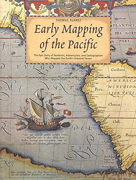
With "Krakatoa proving to be a volcanic event in publishing, interest in Pacific Ocean maps is higher than ever before. But while current maps are useful, the antique maps truly fascinate. Ancient maps of Oceania hold mysteries as old as time--were these early guides molded as much by fantasy as fact? Why did map-makers take liberties with some of their subjects? "Early Mapping of the Pacific bravely delves into these questions. This book traces the exploration and charting of the Pacific Ocean through rare maps of Japan and the varied islands of Oceania from the 1700s. It follows the story from classical times through the turn of the 20TH century, telling the tales of sea-farers who ventured east ward from Asia and were the Pacific's greatest explorers. Through dozens of vintage maps, you'll learn how Portuguese mariners added major islands in the southwest Pacific to the map in the early 16TH century while Spanish explorers plotted vague specks of land in the vast center of the map. Witness as Dutch discoveries in Australia add significantly to the evolving image of the ocean, while the known islands of Oceania remained few, scattered, and so poorly charted as to be impossible for others to find.
著者簡介
圖書目錄
讀後感
評分
評分
評分
評分
用戶評價
相關圖書


本站所有內容均為互聯網搜索引擎提供的公開搜索信息,本站不存儲任何數據與內容,任何內容與數據均與本站無關,如有需要請聯繫相關搜索引擎包括但不限於百度,google,bing,sogou 等
© 2025 book.quotespace.org All Rights Reserved. 小美書屋 版权所有